East of Kyoto: Southern Higashiyama Neighborhood Walk

higashiyamaCredits: Papers by Designs by Tater from ScrapMatter’s Life’s Little Surprises Kit.

The guesthouse took sometime to find.  Tucked away in a street where cars aren’t allowed.  The driver of our shuttle service eventually found it; he led us into a narrow residential street.

garden-at-entrance

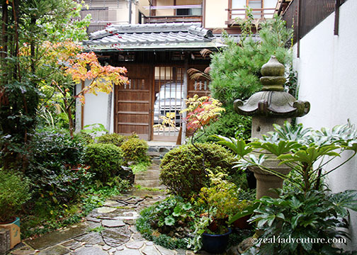
The house is charming, even at night.  A young man let us in, cheerfully welcoming us at 10 in the evening.  The real owners of Yamato Guesthouse are his parents, Kenzo and Nagako.

kenzo-and-Nagako

He was there for the weekend, I figured.  I noticed a group was enjoying some drinks at a corner so I asked if they served dinner — we were hungry, arriving straight from Kansai International Airport.  Of course, they only serve breakfast but they accommodated our request and prepared something simple after seeing our hungry faces.  The other group, it turned out, are friends visiting hence the beer and the snacks – I felt a bit embarrassed about our dinner request.   😯   Such is the hospitality of the Japanese and of our host.

breakfast

Nagako served quite an exquisite breakfast and for 2 days I felt very pampered

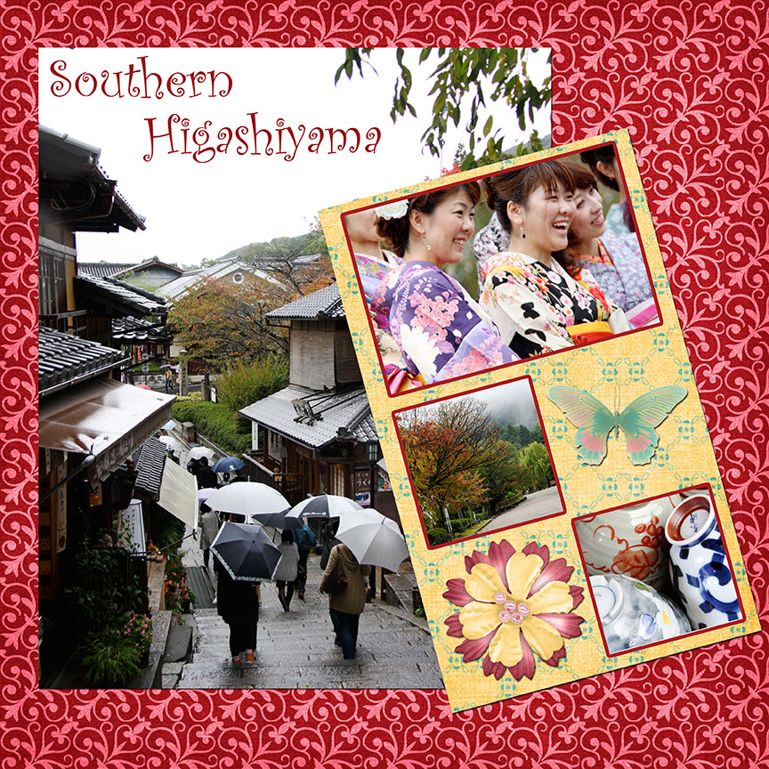
The former capital of Japan is famous for its temples and shrines, a beautiful city with tradition and culture filled to the brim.  Kyoto is one of the oldest cities and there is so much to see.  Even just zooming in on an area – the east side – we still barely scratched the surface.  Two whole days is obviously not enough but that was all we had.  We were merely passing through and we made the most of it.

Yamato, I estimate, is a good 10 minutes stroll away from Kiyomizu Temple — actually, it could be 20 if you window shop and ogle at everything interesting along the way.

store-chawanzaka

The neighborhood consists of many interesting stores, delightful cafe and food stalls, which actually make for a pleasant stroll to the temple.

chawanzaka

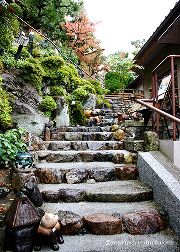
The street of our guesthouse comes out to Chawan-zaka, it actually leads to the temple but we chose instead to turn into a complex that has several flights of stairs,

asahizaka-map
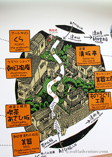
A map of Asahizaka complex

asahizaka-steps

stores and cafes line the way leading to Kiyomizu-zaka, where we chanced on more stores and tourists.

kiyomizuzaka-from-temple
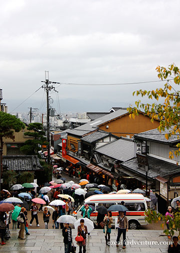
Kiyomizu-zaka from the temple

If you turn right, you will end up in Kiyomizu Temple.

kiyomizudera

Inside the temple, the tourists escalated in unbelievable proportion.

tourists

Half way through the temple, we gave up and settled for a much-needed coffee break and cream puffs.

Yatsuhashi-cream-puff

Kiyomizu-dera is perhaps the most beloved of Kyoto’s temples.

kiyomizu-temple-entrance

It is a famous hilltop temple offering sweeping views of the old capital.

view-of-the-city-from-kiyomizudera

Popular with tourist and pilgrims, the temple is part of the Historic Monument of Ancient Kyoto and a UNESCO World Heritage Site.

The narrow cobbled street of Kiyomizu-zaka (if you walk away from the temple) will lead to Sannen-zaka and Ninen-zaka, a restored neighborhood oozing with old world charm.

Ninenzaka-and-shannenzaka

Both streets are lined with old wooden houses, traditional shops and restaurants.  It is  a good example of the old Kyoto, the Kyoto everyone imagines.  Despite the drizzle, it was a wonderful walk, quite uplifting I must say.

Following the route suggested by Lonely Planet, we found the street the guidebook described as “the most beautiful street in Kyoto”, Ishibei-koji.  It is a quiet alley lined with high-end restaurants and ryokans.  I saw a photographer taking shots of the street at the end of the stone-paved road.  I went to where he stood and this was what came out.

Ishibei-koji

Have to admit that this quiet street has character with its own stories to tell perhaps but to be identified as “the most” beautiful street puts too much pressure don’t you think?  Beauty is indeed in the eyes of the beholder.  Developed primarily as an area for luxurious rental homes, it is presently a favorite site to shoot TV dramas, movies and TV commercials.

At this point, it was already more than drizzling and it didn’t look like it would let up.  We decided it was time for lunch.

Useful Info:

Guest House Yamato
6-539-23 Gojohashihigashi,
Higashiyama-ku, Kyoto, Kyoto Prefecture
Kiyomizu Temple
1-294 Kiyomizu
Higashiyama-ku, Kyoto, Kyoto Prefecture

East Africa

East-Africa-2

It actually stretches from the northern arid deserts of Ethiopia to the tropical forests of Mozambique and Madagascar, with 19 countries in between.  While my East African adventure in 2006 only spanned 3 countries, the experience it yielded were quite diverse – from the usual Safari adventures to tracking Chimpanzees to the more extreme, whitewater rafting.  Kenya, Tanzania and Uganda, territories that were formerly under British control and each hold common thread yet bear its own unique character.

Highlights:

rhino-and-zebra

Catching sight of the Big Five – Lions, African Elephants, Cape Buffalos, Leopards, and Rhinoceroses.

giraffe

The Big Five aside, Zebras along with giraffes have become favorites.

Witnessing not quite the migration but the start of it.  From July to October, one could witness the great migration where wildebeest and zebra travel to and from the Serengeti National Park to the greener pastures of the Masai Mara National Reserves.

masai-mara

It is perhaps the most breathtaking event in animal kingdom and the whole point of our visit to this continent.  To see them gather together, sometimes in a line is more than thrilling.

flamingos

Witnessing a gathering of Flamingos.  Absolutely a sight to behold, this sea of pink covering a large part of Lake Nakuru.  One of the Rift Valley soda lakes that attract vast quantity of flamingos that feed on the lake’s abundant algae.

Being in beautiful Ngorongoro Crater.  It is the world’s largest intact unflooded volcanic caldera and is home to over 300,000 animals including the rare Black Rhinos.

ngorongoro

An absolutely beautiful place to be on a safari, the crater makes for a stunning backdrop to rich grazing grounds.

zanzibar4

Chilling in Zanzibar.  A semi-autonomous island separated from the Tanzanian mainland.

zanzibar3

Although just a short distance from the Tanzanian coast, it is at the crossroad of Africa, the Middle East and Asia resulting in a culture of diverse ethnicities, more Middle Eastern in its feel than African.  Likewise with local dishes, the rich fragrance of cinnamon, ginger, cumin, pepper and cardamom is synonymous with Zanzibar, also known as the Spice Island.  The streets of Stone’s Town – the capital’s old quarter – is full of the bustle of back street markets and local flavor.

zanzibar2

The charm lies in its labyrinth alleyways and faded buildings redolent of the glories of the old Islāmic empire.

7th-Jul-06-(73)

Rafting the White Nile.  Stretching 31km from just below the Bujugali Falls in Jinja, experiencing the Nile at its source is by far the best heart-pounding whitewater ride of my life.

Getting lost in Uganda.  On a wrong bus, we went the other way and ended up not quite where we wanted to be.

bus-stop-scene-in-Uganda

Best known for Idi Amin or Joseph Koney, getting lost could be frightening but this mishap gave us a taste of the local flare and the kindness of its people.  We eventually found our way but not without the help of the people we didn’t know from Adam.  An impression indelibly marked in my heart.

It is by far one of the best trip I’ve had – a wonderful surprise, considering that it was not even on the priority.  I will be back Africa, sooner than you know.

The Way to Initiate the Novice

trekking-to-lighthouse

I’m with some novice trekkers, not that I mind, it is an easy trek after all.  I am thrilled, in fact, to have them experience the joy of summiting after an uphill struggle that seemed never-ending and pointless, and to realize, after all that trouble, that the reward is usually at the peak.

Named the 3rd best beach and island of the Philippines by CNN Go April of last year and just like that, Palaui caught my attention.  I’ve been going back and forth to Sta. Ana for a few years now, but Palaui was never on my radar.

rough-sea

Maybe because it takes more work to get there and that includes braving the (sometimes) treacherous sea.

approaching-palaui

A protected area, the island lies between the South China Sea and the Pacific Ocean.  It boasts of a nice long stretch of white pebble beach, abundant marine life, a century old lighthouse, a waterfalls hidden somewhere and a scenic rugged terrain.  It is pretty much uninhabited, with only a small community living in the island.  No electricity and accommodation to speak of.

jump-off

So one fine day, along with the same people I spent several Sta. Ana weekends together, we took off from the shores of Sun City in San Vicente and headed to Palaui.  An hour, perhaps more on the boat and we arrived on the island.

Palaui-beach-front

We paid for a guide and started our trek on the beach,

forest

which lead to a short forest walk before we emerged on the other side to beautiful rolling hills reminiscent of Batanes.

like-batanes

steps-to-lighthouse

We then climbed (more than) some steps that would eventually lead to the summit where Cape Engaño stands.

closer-glimpse-of-lighthouse

cape-engano

The view along the way took my breath away.

beach-from-the-top

It may not be the best beach as it is not fine sand as that of Boracay or even Palawan

beach

but the island dazzles at every turn,

dos-hermanas

glimpse-of-the-beach-on-the-way

from the beach to the top of the lighthouse… all I can say was SPECTACULAR.  And the new recruits were enjoying themselves too.

half-way-to-lighthouse

Not that difficult to get to, we took the Lugunzad trail, which took all of just 30 minutes from beach to lighthouse.

P6300834

There is a waterfall somewhere, said our guide, but all this walking made the others hungry.  And so the initiation is over, we will take baby steps and insist on the waterfalls some other time.

gotan-beach

At a beach named Gotan, lunch was already being prepared.   A private beach, we had to arrange to use a few days earlier.  We had a sumptuous meal of everything grilled.

agoho-in-gotan

There, we lounged around, enjoyed each other’s company amidst beautiful Agoho trees.   That’s how to initiate novice trekkers.  Yes?

Best of 2012

Forgive the silence… would you believe that I ushered in the New Year with colds and fever?  But that didn’t stop me from having friends over for the count down. No.  I hope you all had a wonderful holiday.

This-is-forever

Credits:  Quickpage from JSprague’s 4ever kit, created by Brenda Neuberger

2012 has been good to me.  Even with much less travels this year, I’ve managed a few unforgettable firsts.  Here they are; some I have not even posted but will pre-empt:

1.  The Bus Ride to Vang Vieng

bus-to-VV

A 4-hour bus ride from Vientaine on a sleeper bus made for petite Laotians.  Worst was the bunks were meant for (yes) 2 petite Laotians.  We’re definitely far from petite.  So imagine the trip.

2.  First time on a Hot Air Balloon

vang-vieng

Soaring high in Vang Vieng, watching the town wake up.  You get the best view in town, if you ask me.

3.  The Boat Ride to Y’ami

boat-ride-to-Y'ami

An idea that came to fruition had us journeying to the northernmost island of the Philippines on a grueling 3-hour boat ride off Itbayat Island in Batanes.  Why?  I ask the same question many times over.  An experience hard to topple.

4.  A Night in Siayan

siayan

We had to break the grueling boat ride and stay overnight in an island about 1 hour away from Itbayat (the farthest inhabited island of Batanes) because the waters along the Bashi Channel can be treacherous particularly in the late afternoon.  Getting to the island, beautiful as it is, is an adventure in its self.

5.  Hiking Up to Cape Engaño

Palaui-view

Beautiful sight, up there.  That’s all I will say for now.  Watch out for my post – coming soon.

6.  Enjoying an Onsen Bath

hirayu-onsen

While it snowed too.  A totally exhilarating and liberating experience, I dipped in those pools two nights in a row.  Awesomeness.

As for 2013, I’ve got some exciting plans already in the pipeline. I’ve been working hard to get that to fruition over the holidays, truth to tell.  It is going to be an exciting year.  I feel it in the air.  How is your 2013 looking so far?

Random Travel Snaps: The Orangutans of Borneo

orangutan

Threatened by logging and captivity, their population dwindles through the years.  These so-called “men of the forest” are estimated to be as few as 10,000 still in the wild.

In 2007, I followed the path of a boardwalk that led me to a viewing gallery and a feeding platform.  There were a few orangutans on site but slowly, more emerged from the rainforest lured by milk and bananas.  Feeding time is twice a day – once in the morning and another in the afternoon.

No longer held in captivity (by various people and for various reasons), they are free to roam as they please around the 4,300 hectare Kabili-Sepilok Forest Reserve.  This is so they get used to their own natural habitat once more and this –in the meantime – is their sanctuary.

Sepilok Orangutan Rehabilitation Centre aims to return orphaned, injured and displaced orangutans back into the wild, back to the jungle of Borneo.  Orangutans are natives of Borneo and Sumatra in Indonesia.  The Borneo orangutans however, are only found in Borneo, and the centre affords a rare opportunity to see these endangered species up close.

The orangutans may be the star, but pig tailed and long-tailed macaques share a bit of the stage at the time of feeding.  They have learned that there is an easy meal available and show up too at feeding time.

A day trip to Sepilok is not possible from Kota Kinabalu but if you find yourself in Sandakan, a trip to Sepilok Sanctuary is a must.

Useful Info:

Getting There


If you are not on any tour, public buses and taxis are available from Sandakan town. The Labuk Road Bus Company vehicles leave from the front of the Sandakan Town Council (Majlis Perbandaran Sandakan or MPS) from 6.00 am onwards.

The Kota Kinabalu to Sandakan bus can also drop you at junction Jalan Sepilok, around 2.5km from the Center. Journey about 5 hours from KK.

You can hire a taxi for a return trip for about RM100.00 negotiable. The distance between town and the Centre is about 23km.

Opening Hours: 
Daily from 8.00am till 5.00pm

Exhibition Hall: Daily (except Fridays) from 9.00am till 4.30pm

Centre: Daily from 9.00am till 12.00pm and 2.00pm till 4.00pm Fridays 9.00am till 11.00am, 2.00pm till 4.00pm 

 
Address:
Batu 14, Jalan Labuk Sandakan Sabah,
WDT200, 9009 Sandakan Sabah

Rest of Batan: Mahatao

When I think of Mahatao, this simple church is the first thing that comes to mind – not the lighthouse,

Photo taken in 2006.

and certainly not the boat shelter,

An island detached from the main island provides shelter for inter-island vessels.

both constructed sometime around the mid-2000 only.  The church, however, has been a fixture in this old sleepy town since the days of yore and every time I am in Batanes, I get to visit it.

It is, after all, the biggest structure in Mahatao.

San Carlos Borromeo Church is one of the oldest existing church in Northern Luzon that still keep its centuries old features making it a National Cultural Heritage Treasure.

Also part of Mahatao is the Chanarian View Deck.

Another personal favorite, it has breathtaking views of Batan and the rugged cliffs.

Concrete stairs lead down the cliff if one cares to explore the water below.  I prefer the view from the road.

Last May while enjoying the view, I chatted with our guide Mang Rudy about life in Manila.  Life in the capital, as he describe it, is hard enough as a single, sometimes holding 2 jobs just to make ends meet.  When he got married, he knew that it would be difficult to raise a family if he stayed.  So they went back and now that they are settled and has called Batanes home once more, he is happy.  A guide before he left, he picked up where he left off citing that the influx of tourism provides a steadier income.  He is also enjoying the support he gets from his family, friends and neighbors, bayanihan still very much a part of their culture.  Their geographical isolation has a lot to do with this spirit.  He is proud to be an Ivatan, and I can feel his passion.  As a guide he aims to promote his homeland because it is indeed a place so unique and beautiful to be in.

Thor and Anton, taken in 2006 in Diura Fishing Village.  A small village facing the Pacific Ocean and where fishermen perform a ritual to signify the start of another season of fishing.

In 2006, a guy who is not from Batanes, nor is he Filipino brought us around.  Thor, a volunteer is American.  It amused me that a foreigner was showing us around the island, our very own country.   He was then helping the Tourism Office in various projects, one of which is training guides.  I never got to ask Mang Rudy if Thor ever trained him but regardless, I think he will make Thor proud.

And this ends my series on Batanes.  Want a summary of where and what to eat in Batanes?  Check out Batanes Eats at Storm In My Kitchen for some of the island’s gastronomic delights.

Rest of Batan: Rakuh A Payaman

Where wild cattle and carabaos (water buffalos) roam in endless rolling hills – a communal pastureland offering picturesque scenes of farm fields and the Pacific Ocean.

There is also the Mahatao lighthouse and Mt. Iraya in the distance, adding to the already breathtaking view.

Rakuh A Payaman translates to “big pastureland” and as with the rolling hills of Vayang, one becomes just a speck in the midst of the sweeping landscape, the vastness unimaginable.

While horses are a rare sight these days, tourists know it more as Marlboro Country, perhaps resembling the backdrop of a long running cigarette campaign,

Basco Jaunts: Quaint Little Café in Naidi Hills

Heard one of the bunkers in Naidi Hills is now a café.  Open only after office hours because the owners have day jobs.  So I noted to self: to have dinner there tonight.

Naidi Hills used to just be a nice spot to chill and to watch the sunset, nothing there really except for the old bunkers.

These bunkers, forever a fixture and leaves much to be desired, sits atop stunning rolling hills with equally stunning views of the town, Mt. Iraya and the bay.

They couldn’t have picked a better site for the café, finally making good use of the old bunkers.

When I returned in 2007, a 6-storey lighthouse with a viewing deck on the 5th level was a new addition to the vicinity, adding to the Naidi Hills charm.

Built next to it is an Ivatan inspired house that was a guesthouse then, a souvenir shop now.  Guess the guesthouse didn’t pan out so well.

Rows of flowers grown near the house brightens up the already pretty site.
Mt. Iraya peeking out of the clouds as seen from the plaza.

Just a short hike from the town plaza, we walked to dinner passing Sto. Domingo de Basco Church along the way.

Established in 1783, making it the oldest church in Batanes, and perhaps one of the oldest in the Philippines.

Having had our share of coconut crabs in Itbayat already, lobsters were next on our list.

Kinilaw na isda (fish cooked in vinegar), a pako (fiddlehead fern) dish, and inihaw na baboy (grilled pork) complemented the sweet lobsters, steamed to perfection.

When evening came, the mood changed.  The spotlights puts focus on the dinner tables outside and the lighthouse dramatically provides the backdrop, bringing al fresco dining into a whole new level.

Setting ambience aside, Bunker Café is a delight in the food department.  Put pack ambience and the café is definitely a winner.

A must visit when in Batanes.

Basco Jaunts: Vayang Rolling Hills

Credits: Red overlay by Kari Holts or iKari Design.

It is perhaps the most visited in Basco.  This place somewhat epitomizes Batanes in the minds of many… endless rolling hills, blue skies and magnificent views of the sea, the South China Sea.

The first time I made it here, I was mesmerized by the unfathomable vastness, how small one can feel within its green expanse.  In 1998, one has to walk up hills upon hills, no vans, no tricycles, and no paved roads.  You get there by walking on unpaved trail.

A trip to Batanes then needs at least 5 days for a complete walk through of Batan and Sabtang.  Those were the days – though I still get goosebumps, I think I like it better then. I can’t deny though that the comforts of today made it a pleasant revisit, especially on a hot summer’s day in May.

The scenery of Vayang is so immense no photo can capture exactly the true essence of the place.  Having said that, here’s an attempt on capturing even just a bit of its flavor and spirit.

Basco Jaunts: Valugan Bay

Credits:  Quickpage by Antonia Krajicek using the “4Ever” kit, a collaborative kit created by Jessica Sprague.com; Suede Alpha by Miss Behaving 2011.

From where we got off, I could hear the splash of the waves; the boulders hardly visible.

The sea is calmer in May.

The rambling of the rocks that hits the ocean floor becomes clearer when you are closer.

With picture-perfect spots scattered all over the islands, Batanes is easy to love.  To pinpoint one specific spot that I love the most is a tall order and perhaps impossible.

Valugan Bay though is so different from any beach I’ve seen, it has left indelible memories and has landed on my top 10 lists of favorites.

I’ve never come across any beach as dramatic as Valugan Bay.

Spewed out by Mt. Iraya and polished through time by powerful waves of the Pacific Ocean, large multi colored rocks covers a kilometer stretch of beach

Taken February 2006 when the waves were larger.

and made more mystical by the ocean mist when waves are strong.

The rambling of the rocks soothes my senses every time I’m here.

The troubles of my world easily fades into a renewed spirit as God whispers through those ramblings that everything will be as polished as those beautiful rocks.   I could sit here forever.