My New Paradise

AdamsCredits: JSprague Digi in Deeper course material.

Adams.  A familiar name yet peculiar for the Ilocos Norte, yes?  With names like Laoag, Pagudpud, Paoay… Adams sounds off.  The first time I heard of Adams was 16 years ago when Anton explored the river with fellow guides. He raved not only about the river but its natural surroundings as well.at-the-river

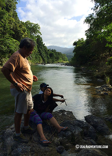
He went back several times to raft and to kayak the Bulo River but never with me. In 2009 on an Ilocos Road Trip, we attempted a visit to Adams to hike to the waterfalls. It rained, and we chickened out.  We never made it to the town.

2009-Adams
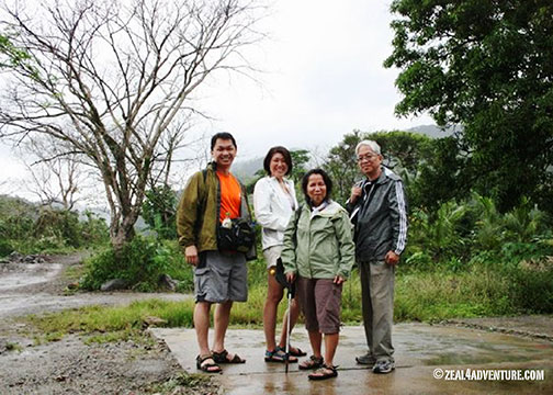
This was at the junction where we’d take a habal-habal (motorcycle for hire) to take us to town.

view-of-the-town
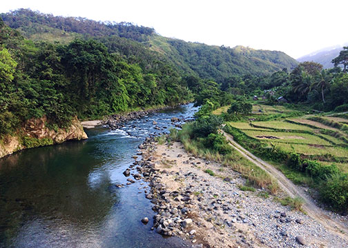
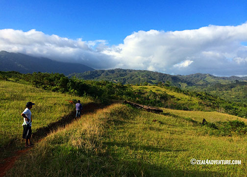
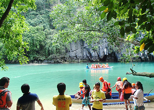
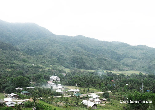
Sprawling over a land area of 159.31 square kilometers on the northern coast of Ilocos Norte,

flora
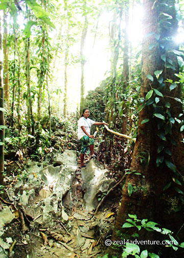
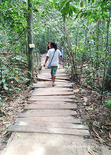
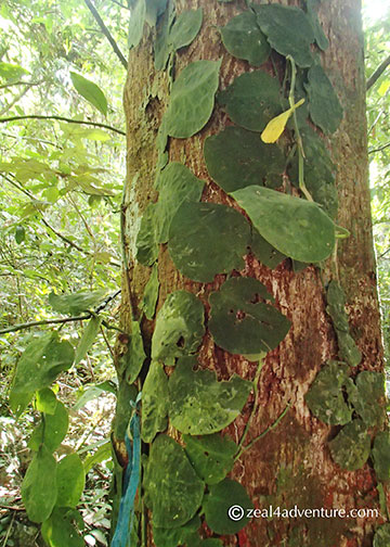
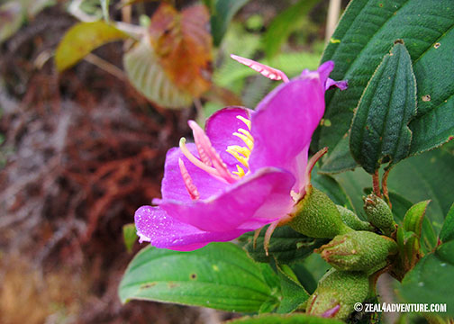
Adams is a treasure trove of rainforests with rare flora and fauna, centuries old trees,

hanging-bridge
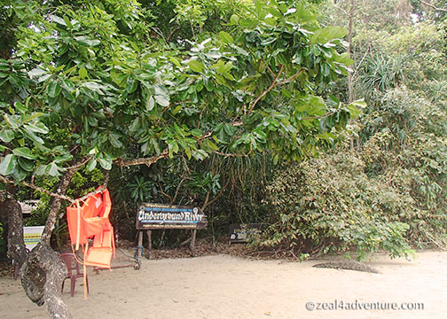
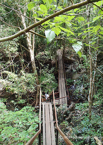
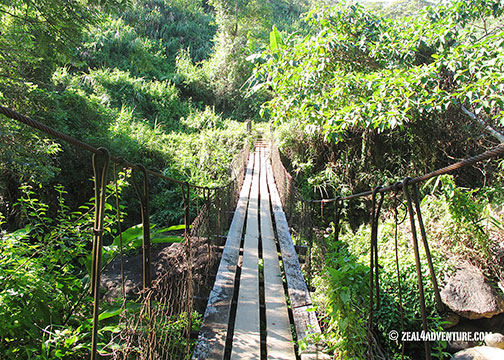
hanging bridges and waterfalls.
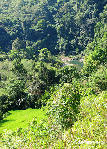
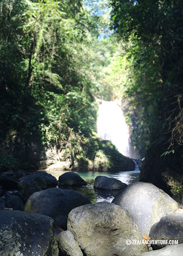
anuplig-fallsAnuplig Falls
cultural-dance
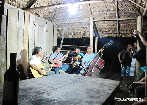
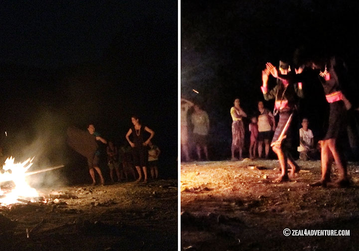
We were treated to a cultural show.

It is a small town of only one village but is a melting pot of ethnic groups composed of the Yapayao or Itneg, Ilocano, Igorot, Kankan-ay and Ibaloi, which explains why their cuisine is different from the Ilocano dishes we know.

local-produce
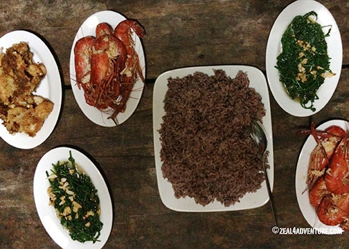
We had fried frog, udang (river shrimps), stir-fried pako, and mountain rice.

It is a hodgepodge of the various ethnic groups and what is locally available like gabi (Taro), crab lets, baby damo (wild boar), frogs, Udang (river shrimps), purple mountain rice, and my favorite, stir-fried pako (fiddlehead fern).

baguio-climate
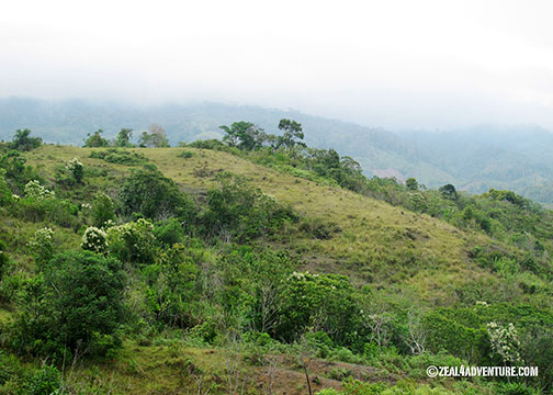
Like its name, it is a divergent from the rest of the region.  The climate is pleasantly cool especially at this time of the year, with temperatures just a few notched higher than Baguio.

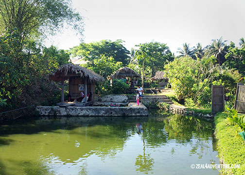
I wish I had made more effort to visit this mountain-river town. It took me fifteen years to finally set foot here. My first trip to Adams was last year around this time. Ask me how many times I’ve been back since. Four so far. I have fallen in love with the area. Expect more posts from me. Meanwhile, here are some photos to whet your appetite for the place.  This is my new paradise.

bulu-riverThe Bulo River from a bridge.
enroute-to-anupligLush forest en route to Anuplig falls.
entertainmentHospitality to the hilt.  Entertainment provided by the villagers.
Ilyn's-HomeystayIlyn’s Homeystay: our home in Adams.
lover's-peak-2A beautiful point called “Lover’s Peak”
lover's-peakLovely grounds at Lover’s Peak.
Advertisement

The Trek to the Underground River

Underground-RiverCredits: Papers by Plum Dumpling Designs, Pri Rocha, The Design Girl, Trixie Scap Design; Ribbon by Design by Tater, Red string with flowers by Graham Like the Cracker, and String wrap by Haynay Designs. 

Elusive in the past, I became disinterested and eventually gave up the idea of visiting Palawan’s famous Underground River. Then they re-opened the Jungle Trail.

Initially slated for December but due to unforeseen reasons, we moved our Puerto Princesa trip to January.  We planned to simply chill out, visit our favorite jaunts and catch up with friends. Then, the grand idea— “why not go to Sabang for the day so you can finally see the Underground River?” Anton to me.  Me to him,  “Ok, but we will trek to the cave.”

Sabang-Pier

The Sabang Pier is the main jump off point to the Underground River or The Puerto Princesa Subterranean River National Park, once also called the St. Paul Subterranean River. Yes, it has many names. A UNESCO World Heritage Site since 1999, the cave was provisionally chosen (through votes—and you know how we Filipinos can vote) as one of the 7 New Wonders of Nature in 2011.

Entrance-from-the-shoreEntrance from the shore

The usual way to get there is to take a 15-20 minute boat ride (I estimate) from the pier.

There are two trails to the cave, The Monkey Trail, and the Jungle Trail. The former has been closed for a time now and the latter re-opened only last year. Having heard of the Monkey trail from friends who did it some 10 years back, I knew that I’d do it at some point. Well, the jungle trail, I reckon, is good enough.

crossingThe trek starts by crossing the mangrove.

A recommended option for the active, the jungle trail meanders through a beautiful lush forest.

dwarfed-by-trees

It lets you hike through ancient trees, well crafted wooden staircases, bridges and benches made from confiscated wood that adds character to the trail

wooden-walkways

one-among-many-bridges

and at one point, limestone formations becomes backdrop behind the foliage.

limestone-backdrop

Not only does the pleasant 2-hour hike enhance the experience but it also gives jobs to the 20 or so Tagbanua indigenous community members.

guide

reminder-before-the-trek

As “Park Wardens” they serve as guides and caretakers of the jungle.

path-to-the-riverthe path from the trail

The Underground River itself was not a let down at all. Having heard of so many mixed reviews, expectations were low.

paddle-boatsWaiting in line to enter the cave.

But to my surprise, the chambers especially the one called “the cathedral,” towering some 800 meters high, impressed me.

inside-the-cave

Truth to tell though, I fell asleep some part of the way, perhaps due to exhaustion and the fact that the only thing lighting the way was a flashlight held by the person in front. Our guide was adept and quite engaging in providing intelligent albeit elementary information about what a cave system is.

lush-forest-2

My take on this experience: to go there just for the Underground River may not be worth the effort (it’s still a 2-hour ride to Sabang). The hikes makes the difference.  Having seen Sabang, I wish I had stayed a few nights to explore the quiet town.

Torongan Cave: Not To Miss in Itbayat

When asked about the places I have liked the most in my travels, high up there with Africa, my answer would always include Batanes. When I look back at the adventures I had in this northernmost province of the Philippines,

our trek to Torongan cave in Itbayat was a highlight for sure… the state of wonderment, unforgettable.

It was a 20-30 minute hike from a gate to the cave entrance, passing through a forest.

And from this spectacular cave entrance is a relatively easy walk down the large cavern leading to a wall that opens to the sea.

This opening is believed to be the entry point of the Austronesians from Taiwan to the island some 4000 years ago. An excavation done on Torongan cave in 2004 uncovered the oldest artifacts so far found in Batanes.

But it isn’t the cave per se that impressed me.  We exited the cave where we entered,

we walked further and found ourselves climbing up some boulders to a rocky pasture land,

revealing the coast, and Dinem Island in the distance, a view so jaw-dropping beautiful.

The dramatic change in scenery atop the cave was an experience stuck in my memory to this day.

We wandered around in awe.

The view majestic at every turn.

Walking back, we passed through several ancient burial grounds shaped like a boat, albeit hard to discern.

If you have limited time in Itbayat, make Torongan cave your first stop and be awed.

Siayan

We scrambled through rocks, walked through pastureland until we reached a beautiful beach.

As with Y’ami, a shore entry wasn’t possible.

The boat took shelter at one side of the island, hidden by a cove of volcanic rocks; the boat is safe there for the night.

We, on the other hand, had only a tarp to shelter us for the night.

If it rains, we’re doomed.  And as thunder rumbled and lightning flashed through the night, deep sleep eluded me.

Siayan Island is about 1km in diameter.  It is 164m high and is considered an inactive volcano hence the rocky path to the beach.

Lying about 8 km north-northeast of Itbayat, it is just an hour away from the farthest inhabited island of Batanes.

Itbayat in the distance.

The water can become turbulent however and our guides took precaution and insisted we stay the night in Siayan.

When they said that the island has a water source, I had in my mind a stream tucked away in a forest somewhere.  Instead, it is more of a concrete rain catchment built on top of a hill.  The water stored there is only for bathing, not for drinking.  We took turns rinsing ourselves and I should add that the view on this hill is spectacular.  I meant to take a photo but unfortunately never got around to doing so because I don’t normally bring a camera with me when I take a bath, do you?  So I keep forgetting.

Dinner and bedtime was early because we were tired from the day’s excitement and there really wasn’t much to do after dark.

Breakfast Feast prepared by our guides.

The walk back after breakfast was another struggle – going down this time.

Definitely not a walk in the park.

A glimpse of our boat from the top.

Back in Paganaman port, we walked up steep steps (with our stuff) to the road where our truck will return for us.

Waiting for our ride.  Tired from the journey and the sleepless night.

A grueling trip worth all the experience.  Will I do it again?  Perhaps not back to Y’ami, but to other unexplored territories, hell yes.  As I always say, I’ll do (almost) anything at least once in my life.

Kuang Si Falls

Picturesque and very accessible – Kuang Si falls, 29 km south of Luang Prabang, has become a popular attraction outside of the world heritage city.  Surrounded by lush forest, the falls is 3 tiered, all picture perfect.

The breathtaking main falls is 60 meters high while the rest, equally stunning, are 1-3 meter cascades that creates small aquamarine pools.

The water invites especially on a hot day, many take a dip, some even take to jumping off trees for some thrills.

A forest trail leads the top of the falls where you’ll find the source of the Kuang Si in a stream.

The surrounding area was developed into a lovely park with bridges, a picnic area with tables and even a changing room for those wanting to swim.  My journey to Kuang Si wasn’t as easy as taking a tuk-tuk to the entrance of the park.

It started when a van picked us up and dropped us off (an hour later) at a Hmong community.

There we learned the difference between the Hmong as compared to the rural Lao lowlanders.  To get to the falls, we trekked through paddy fields and pineapple gardens before entering a rain forest.

Halfway through our trek, we stopped for a simple Lao lunch prepared by the outfitter.

About 3 hours later, the hilly trail took us to a stream that we soon realized was the stream feeding the Kuang Si.

The view from the top looking down the pool below was spectacular.  Expecting to approach the falls the regular way from below, the realization of ending at the top was a wonderful surprise and quite memorable, truth to tell.

I made this trek 4 years ago with Green Discovery.  Spare an extra day for this if you can, it’s worth the effort.

Bomod-ok Trek: Ten Things Before

Credits:  All materials used from JSprague’s Digi in Deep Lesson kit.

A visit to Sagada is not complete without doing one or two of its more popular activities –

trek to Bomod-ok falls, explore Sumaging cave or

traverse to Lumiang.  If you are a thrill-seeker, than you MUST do all three and more.  If, however, you’re not as daring,

I would still recommend venturing out to the falls, if only for the scenery.

If doing such a thing is stepping out of your comfort zone, here are some tips on how to prepare for it and what not to miss while at it.  You’ll never know what might spark after this experience.  One has to start somewhere, I certainly did and trekking these terraces started my love for the outdoors more than a decade ago.

1. Take a heavy breakfast

Lots of carb.  You’ll need the energy – for sure!

2. Bring lots of water

You’ll want to hydrate even if you don’t feel the heat.  Walking 3-4 hours even on cool weather will definitely make you sweat.

3. Wear swimwear underneath

I’m a sissy.  I could never brave the icy water.  The refreshingly blue pool however entices many and you might be one of them.  Be prepared.

4. Wear good footwear

Nothing ruins a good trek more than the wrong footwear.  Make sure you use a comfortable pair of walking shoes preferably with good traction.  I discourage using Crocs, as much as I find them comfortable – it is not made for trekking.  A good pair of rubber shoes is fine.

5. Use a light jacket

Unless it’s sometime between Nov-Feb when the weather is coldest, a light rain jacket should suffice to protect you from the wind and keep you dry when it rains.  A thick jacket will be too hot once you start to perspire.

6. Book a guide

Very important.  Even if it is the nth time to trek the path, one is still obliged to register at the Sagada Tourist Center near the town hall and book a guide for the group.  This is to make sure that everyone is accounted for after every activity.

7. Exhibit proper decorum

Talk to the village folks, don’t just snap away.  Give way to uphill trekkers and those carrying heavy stuff.  Also, don’t let the faster trekkers intimidate you, let them go first.

8. Take lots of photos

You’ll be walking along the terraces with the mountains on the background,  you’ll kick yourself for leaving that camera behind.  There are pretty sites after pretty sites so don’t forget the camera.

9. Bring snacks along

I prefer trail mixes to chips – they’re healthier.  I combine mixed nuts and dried fruits (I like raisins, cranberries and some dried mangoes cut into bite-sized pieces).   This will get you by until lunch.

10. Prep the body

Prior to the trek, walk more either around your neighborhood or on a treadmill.  This way, your body will not take too much of a beating after a wonderful adventure.

The Way to Bomod-ok

This looks like an ordinary rice plantation, zoom out a bit and it’s no longer so ordinary.

Zoom out further and you will see why I love trekking to Bomod-ok falls, sometimes called the “big falls”.

The falls can be blah at times – I say this when it’s the dry season and it does not really live up to its name.  Yet, whatever greets you at the end is beside the point… it’s the journey that I enjoy so much.  It starts at the basketball court of Banga-an village passing through several other villages.

The last village, Fedelisan, is where you will have to register and pay a fee of Php 10 to pave and maintain the trail.

I like hanging out a bit at the village, the people are friendly and the kids adorable.

The different trails along the way.

Having walked this trail so many times, I was amazed at how easy it is to navigate through the rice paddies today.

Just another playground for the village kids — running around the “unpaved” path.

I remember having to balance myself as I make my way through the wet rocks that was once the trail.   So methinks Php10 is not asking for a lot with the obvious improvements.  But I digress…

Pass the village is a spectacular view of the Fedelisan terraces – one of my favorite sites, truth to tell.

From here to the falls, you will ooh and aah from the different landscapes along the way except for an eyesore I spotted on this recent trip –

gold mining, I was told.

A couple daring kids running around on their birthday suits having loads of fun.

Once you reach the falls, what will greet you will be tons of people and kids who made the falls their playground.

The falls this time, albeit not the strongest I’ve seen, is a pretty sight.

Swimming is allowed if you dare dip into the freezing water.

Walking through the sceneries makes the 3-4 hour trek (depending on your fitness level) a breeze.

Even this is forgiving once you reach the top.

We always like ending the trek through a village called Aguid because its terraces are just so awesome.  From Fedelisan village, take the right trail to get to Aguid.

Less of the cemented walkway and more of the dramatic twists and turns of the rice paddies.  Awesome… but I said that already.

This halo-halo is different as it has macaroni in it — interesting just because it isn’t as sweet owing to the tasteless pasta.

At the end of the trail is a halo-halo stand.  Gotta have some of those to complete your whole Bomod-ok experience.

We capped our morning adventure with a delectable lunch at Yoghurt House. 

A cozy café in town that serves more than just superb yoghurt.  See why I love it so much here.

Sagada: Echo Valley, Hanging Coffins et al

When we passed this sign, my heart skipped a beat because in just another hour or so, I will be re-acquainted with my favorite town.  The town I want to retire in, I always say.

When I need to de-stress, Sagada comes to mind.  Or when I find myself without a place to go on a long weekend, Sagada comes to the rescue.  But truth be told, I don’t really need a reason to go to Sagada… for more than a decade now, I find myself there just because I miss the smell of pine, the food or the bucolic serenity (as shown here, here and here).

I lost my heart to Sagada some 17 years ago.  Although less rustic than it was then while more and more tourists are seen each year, Sagada remains to be a top choice and a go-to to recharge.

And St. Joseph Inn still is a favorite lodging place. We like the cabins but the rooms are perfectly fine too.

It has become some sort of tradition, if I may call it that, to hangout – finishing a few bottles of wine or beer at the comfort of our cabin.

St. Jo is at the center of town and just a stone’s away from St. Mary’s Episcopal Church,

a charming little church with beautiful stained glass windows built by the Anglicans.

On certain times of the day, the light coming in from these windows makes for a dramatic interior.

Because it takes only a short walk to Echo Valley from St. Jo, we like visiting it as soon as we arrive.

Passed the church is a path that leads to the cemetery

and further along is a dramatic hillside trail to Echo Valley –

attributable to the weather-beaten limestone formations scattered around the forest.

One can hear a very distinct echo at a certain point on the hill hence the name.

At one point, one can see from a distance, coffins hanging from the limestone walls.

A trail will lead to it up close. It is a good warm-up hike to prepare for a longer and more scenic one the next day.

A comforting dinner at Masferré Inn and Restaurant is always a fitting cap to a full day. Named after the owner Monette’s father-in-law, the late Eduardo Masferré – widely regarded as the Philippines’ father of photography.  Half Spanish, half Kankanay, he spent much of his life toiling the farm and photographing the Cordilleras, documenting the now vanishing culture of the ethnic groups of the Ifugao region.

Some of his works are displayed in the dining area.  The Masferré Gallery down the road from St. Theodore’s houses more of his works.

“The description is not the described; I can describe the mountain, but the description is not the mountain, and if you are caught up in the description, as most people are, then you will never see the mountain.”

Jiddu Krishnamurti

Useful Info:

St. Joseph Inn
Contact: Julia Abad
Mobile:  (63) 928-951-7156

Eagles and Muskegs

Our journey continues on to Haines.

And here we went around with a naturalist bringing us through the “Valley of the Eagles” to view Haines’ most popular wildlife, the bald eagle hence the christening.

Powerful spotting scopes afford up close views of the eagle and other wildlife.  One can also take photo through the scope.

Year round resident eagles total approximately 400 but the population swells to at least 4,000 in the fall months of October – December.  More than the 2,400 locals residing in this small town.

We then stopped along the shore of a picturesque mountain lake before walking through an ancient muskeg beneath hemlock and spruce trees.  Coming from the Philippines, I’ve trekked many a tropical rainforest and experiencing the sights, sounds and scents of a temperate rainforest was a morning well spent.

Temperate rainforests are less humid, cooler and has more sunlight coming through making it more pleasant to walk through, to compare with the rainforest I know.

I noticed though that moss and algae covers more grounds and trunks in a temperate forest.

Some wildflower shots around Haines.

Firewood

Nootka Lupine

Chocolate Lily

Catching the Sunset: Mt. Manabu

mwtsquare

Maculot

Sounds like a plan?  Yes, and a good one actually.  On Ninoy Aquino Day (his death anniversary), we were to drive to Sto. Tomas, Batangas City, have Bulalo (Bone Marrow) for lunch at Rose Sister of Grace, hang out at O’s house till 3pm and start trek soon after.  Get to the summit in 2 hours or so (that would be sometime before 6pm).

sunset

Catch the sunset, enjoy the view and do a night trek back.   A good plan.  Except for one small detail, we didn’t plan for an overnight.

trail

The trek to the peak was pretty much a walk in the part except for a few steep trails nearing the summit.

trail-to-summit

Approaching the summit, we passed by the campsite and it had me wishing for our own tents so we could stay longer and enjoy the sunset, the view and it’s pretty surroundings and not have to rush back down…”next time”, I made a mental note.

campsites

maculot-upclose

A glimpse of Mt. Maculot

mountain-range

And after the sun set, we started our descent (as planned), stopping by Mang Pirying’s mid way through the trail for some BEST TASTING kapeng barako (local coffee) cooked the old fashioned way – boiled with a hint of sweetness.

Mang-Pirying

Mang Pirying

Mang-Pirying's-wifeNanay Genia

Ahhh!!!  A great energy booster it was.

coffee

Before 9pm, we were back at O’s with dinner waiting for us after we all showered.  That’s what you call perfect hosts.

appetizer-at-OSome Jamon Serrano and Cheese before dinner, anyone?

A massage before bedtime had us sleeping like babies.  We woke up still with our bodies sore but revitalized nevertheless.  So do I still wish for that overnight at the summit?  You. Bet.

From Breakfast, we headed on to lunch at Casa Rap for more good food and nice ambiance.  Now that’s what you call a great weekend!

casa-rap-sign

casa-rap-

crispy-pata

Crispy Pata (Deep Fried Pork Leg)

ice-cream

Ice cream with a little “lambanog” (coconut wine)

More on other worlds, click here.